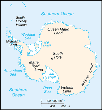
Antarctica...
Stats...
Overview:
Speculation over the existence of a "southern land" was not confirmed until
the early 1820s when British and American commercial operators and British
and Russian national expeditions began exploring the Antarctic Peninsula
region and other areas south of the Antarctic Circle. Not until 1840 was it
established that Antarctica was indeed a continent and not just a group of
islands. Several exploration "firsts" were achieved in the early 20th century.
Following World War II, there was an upsurge in scientific research on the
continent. A number of countries have set up year-round research stations on
Antarctica. Seven have made territorial claims, but not all countries recognize
these claims. In order to form a legal framework for the activities of nations
on the continent, an Antarctic Treaty was negotiated that neither denies nor
gives recognition to existing territorial claims; signed in 1959, it entered into
force in 1961.
Population: No indigenous inhabitants, but there are both permanent and
summer-only staffed research stations
Location:
continent mostly south of the Antarctic Circle
Map references:
Antarctic Regions
Area:
Total Area: 14 million sq km
Land Area: 14 million sq km (280,000 sq km ice-free, 13.72 million sq km
ice-covered)
Comparative Area: slightly less than 1.5 times the size of the US
More Antarctica Facts...
